下班回家收到了猫泽西他妈提前送给我的又一件生日礼物:森海塞尔(Sennheiser) PX100 耳机。
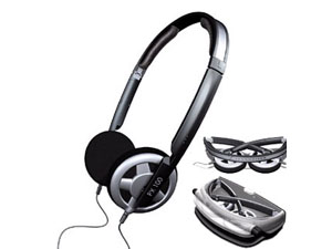 刚好昨天下载了 Engima 的 A.Posteriori 专辑,果然效果比我原来的飞利浦要好很多。据说这个 PX100 低音效果好,还真是。这里有篇评测,真够专业的,写这个东西看起来比搞 Oracle 难多了。不过那个 PX200 的样式我倒是不喜欢。泽西他老妈还挺会买,隆重表示感谢!
孤陋寡闻,这个牌子看来是不少发烧友的最爱,幸亏我不是发烧友,有的型号真的很贵,反正在我眼里看起来挺贵的,嘿。
原来用的飞利浦耳机还是两年前我来杭州的时候买的,已经快用破了。网上搜了一下,型号是 HM-385。
我是个对电子设备不怎么感兴趣的人,家里的数码相机和 iPod 什么的买回来很少拿出来用。不止一个同事说过我"土",我承认。
要改变一下,像个 Geek 的样子嘛.
嗯,再听一下《蓝色骨头》
--EOF--
刚好昨天下载了 Engima 的 A.Posteriori 专辑,果然效果比我原来的飞利浦要好很多。据说这个 PX100 低音效果好,还真是。这里有篇评测,真够专业的,写这个东西看起来比搞 Oracle 难多了。不过那个 PX200 的样式我倒是不喜欢。泽西他老妈还挺会买,隆重表示感谢!
孤陋寡闻,这个牌子看来是不少发烧友的最爱,幸亏我不是发烧友,有的型号真的很贵,反正在我眼里看起来挺贵的,嘿。
原来用的飞利浦耳机还是两年前我来杭州的时候买的,已经快用破了。网上搜了一下,型号是 HM-385。
我是个对电子设备不怎么感兴趣的人,家里的数码相机和 iPod 什么的买回来很少拿出来用。不止一个同事说过我"土",我承认。
要改变一下,像个 Geek 的样子嘛.
嗯,再听一下《蓝色骨头》
--EOF--
